All proposed roadway construction projects and street closures should be emailed to developrequest@hrsd.com for review. Please include “VDOT Project” or “Roadway Project” as part of the email subject line as this will help the tracking system assign the proper level of review. HRSD’s online GIS, which can be used to locate HRSD infrastructure and determine a project’s proximity to existing assets, can be found on the GIS Public Viewer map services site.
Project Information Form
Without exception, all persons must fill out and submit a completed form to the HRSD Hydraulic Capacity Section (HCS). This form must be accompanied by a GIS or other computer digital generated map to indicate project location.
The flow chart below illustrates our review process and construction coordination to address conflicts and/or betterments associated with roadway improvements
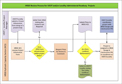
HRSD Review Process for VDOT and/or
Locality Administered Roadway Projects
(click to enlarge)