What is the Potomac Aquifer?
The Potomac aquifer is the largest and deepest aquifer in eastern Virginia and its primary groundwater supply. It spans across the majority of the Atlantic Coastal Plain Aquifer System, underlying the eastern United States from Georgia to New Jersey.
How is overuse damaging our aquifer?
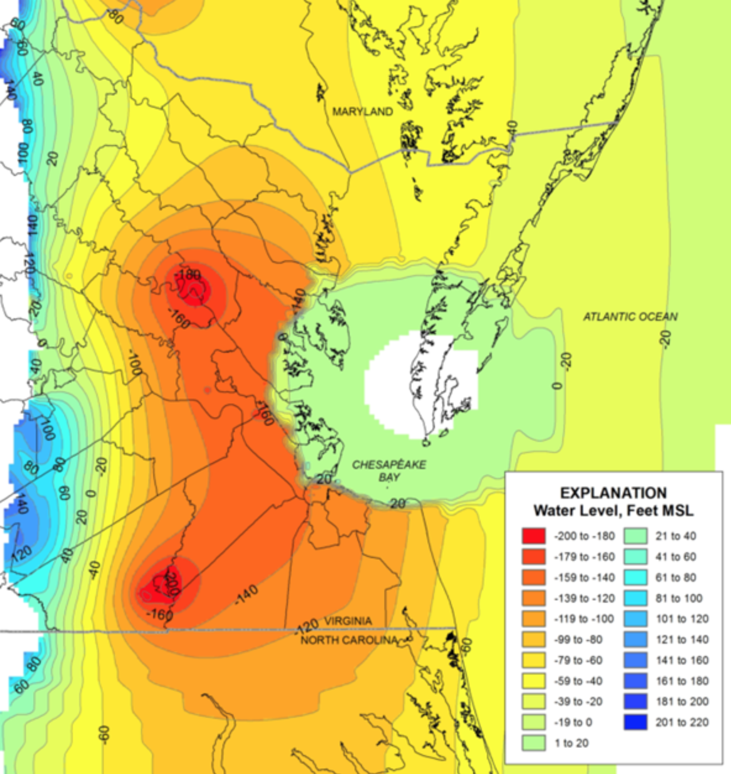
The Potomac aquifer is several thousand feet thick and contains hundreds of trillions of gallons of pressurized water. Unfortunately, this seemingly never-ending resource is being overused. Homes and industries in eastern Virginia remove approximately 155 million gallons of groundwater from the Potomac aquifer every day, drastically decreasing the pressure of the water confined within. This decreased pressure has led to the need for deeper wells to access groundwater as well as aquifer compaction – and ultimately, land subsidence and vulnerability to sea level rise and salt water intrusion.
Precipitation eventually travels through permeable ground layers and recharges groundwater supplies in many aquifer systems. However, since the Potomac aquifer is almost entirely surrounded in clay and bedrock confining units, this precipitation becomes part of the groundwater supply very slowly – predominantly only along a narrow band at the Fall Zone. If groundwater users in eastern Virginia were to stop using this resource today, it would take tens of thousands of years for the Potomac aquifer to return to its original state.
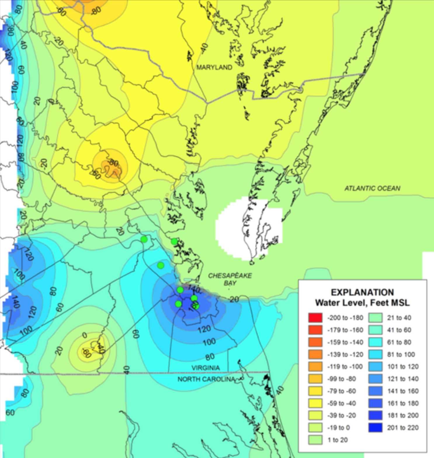
HRSD’s first phase of SWIFT implementation includes two full-scale facilities currently under construction at the James River and Nansemond treatment plants, which, once completed in spring 2029, will be capable of replenishing the Potomac aquifer with up to 50 million gallons of drinking-water quality SWIFT Water® per day. This would:
- Help slow the rate of land subsidence
- Create a sustainable source for groundwater replenishment
- Help protect groundwater from contamination due to saltwater intrusion
Replenishing our groundwater for generations to come
SWIFT proactively considers the needs of eastern Virginia’s groundwater users while improving our region’s environmental resiliency – and protecting a diminishing resource. Hydraulic modeling suggests that this initiative may reduce land subsidence, combat sea level rise, and positively impact nearly the entire Potomac aquifer, as far north as Maryland and south beyond the North Carolina border. With the addition of 50 million gallons of SWIFT Water® each day, the model also predicts that the aquifer can increase the availability of groundwater as far north as Maryland and as far south as North Carolina.
Basic geology
Aquifers are underground bodies of permeable sediments (sand or gravel) that can contain or transmit groundwater. They are separated by confining units made of dense clay or bedrock. The water in confined aquifers is almost entirely surrounded by confining units and is pressurized – the only way to release water from the aquifer is by drilling through the top confining unit layer. In some cases, the pressure in a confined aquifer is so great that when a well is drilled, groundwater naturally travels to the earth’s surface and forms an artesian well. The Potomac aquifer is a confined aquifer that once formed artesian wells prior to being de-pressurized. The permeable sediments in unconfined aquifers are not completely surrounded by confining units and the water inside is more easily accessible – sometimes with just a shovel. When you dig a hole in the ground and reach the water table, you have accessed an unconfined aquifer. The Atlantic Coastal Plain Aquifer Systems consists of numerous confined and unconfined aquifers. The Potomac aquifer in Virginia comprises part of the regional Potomac aquifer system, which also includes the Potomac-Patapsco aquifer and Potomac-Patuxent aquifer in Maryland, Delaware and New Jersey.